Using IRIS Explorer as a Visualisation Web Server
by Jason Wood, Helen Wright and Ken Brodlie, University of Leeds
 The World Wide Web (WWW) has been receiving an enormous amount
of attention for some time due to the way in which it allows us all to share
data spread between a variety of sites on the Internet. Over the past few
months, it has also been used as a mechanism to distribute compute tasks and
calculations across different locations as well. With the emergence of the de
facto standard Virtual Reality Modelling Language (VRML) (External) we are now able to send 3D scenes and
objects across the web for remote viewing of, amongst other things, visualised
data.
The World Wide Web (WWW) has been receiving an enormous amount
of attention for some time due to the way in which it allows us all to share
data spread between a variety of sites on the Internet. Over the past few
months, it has also been used as a mechanism to distribute compute tasks and
calculations across different locations as well. With the emergence of the de
facto standard Virtual Reality Modelling Language (VRML) (External) we are now able to send 3D scenes and
objects across the web for remote viewing of, amongst other things, visualised
data.
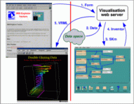
We have been investigating the feasibility of creating a Visualisation Web
Server based on IRIS Explorer (External) which uses these features. The architecture of the server includes a number
of parts: a User Interface implemented using HTML and a web browser; a visualisation
server which utilises IRIS Explorer as its visualisation engine; and a VRML
browser for viewing the resulting visualisation. The user accesses the server
as a page on the WWW; this is a form containing a number of fields to be
set by the user which control not only the selection of the data to be visualised
but also the visualisation parameters. On submission of the form a Common
Gateway Interface (CGI) script is executed on the web server machine which
extracts the information in the form. This in turn is passed to the visualisation
server where it is used to set parameters in the map that is run by IRIS
Explorer. The map is executed and the resultant geometry is given back to
the visualisation server as an Inventor file. This server translates the
Inventor file into VRML1.0 format, before being transferred back to the
user's client, where it is delivered to an appropriate VRML browser. The
diagram above illustrates the process.
We based the Visualisation Web Server on IRIS Explorer because its native
format for geometry is Inventor. Since this is also the precursor of VRML
it was particularly easy to produce VRML from IRIS Explorer.
The server idea has been demonstrated at Leeds as an education application
for MSc students taking a visualisation module, to illustrate the way in
which various visualisation techniques can be applied to data. The advantage
of this way of working is that the student is free to concentrate on the
results of applying a technique, rather than on the details of how it is
invoked in the map. Another application we have developed is the visualisation
over the WWW of air quality data, collected in real-time from a number of
sites around the UK. More details of this application and the system in
general are to be presented in a paper entitled "Visualization Over the
World Wide Web and its Applications to Environmental Data" at IEEE
Visualization '96.
Last modified: Mar 16 17:14 1999
[
Previous Article :
Render Home :
Next Article
]
© The Numerical Algorithms Group Ltd, Oxford UK. 1999